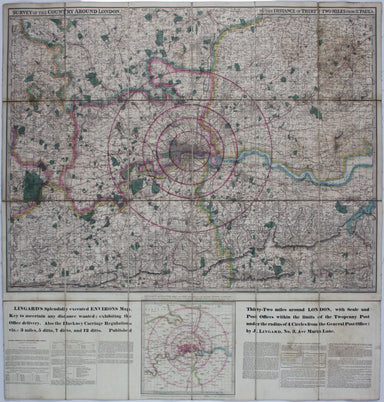
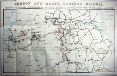
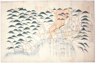
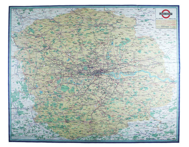
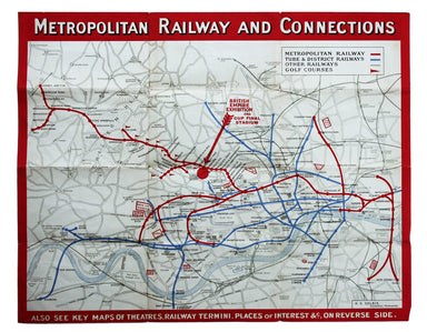
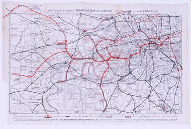
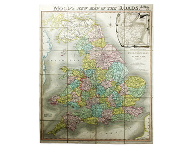
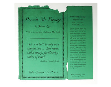
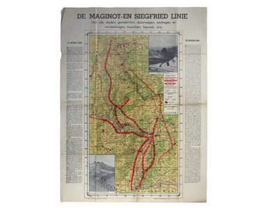
La Feuille's Map of the British Isles
The cartouche on this map of the British isles is surmounted by the old Stuart coat of arms and the borders are made up of sixteen regional armoria...
View full details
The cartouche on this map of the British isles is surmounted by the old Stuart coat of arms and the borders are made up of sixteen regional armoria...
View full details
Condition & Materials Copper engraving, 21 x 25.5 cm, original hand-colour, on a folio leaf 37 x 29 cm, blank verso.
This intricate anthropomorphic map (the artist also produced a zoomorphic companion piece) was issued soon after the outbreak of the First World Wa...
View full details
This is a view showing London before the Great Fire, from the South Bank of the Thames, including London Bridge and old St Paul’s. Principal buildi...
View full details
This map of County Durham was engraved by J & C Walker after Creighton for Lewis’ Topographical Dictionary. Condition & Materials Steel eng...
View full details
Benjamin Getzel Lewis' map of the London underground shows the Victoria Line under construction in the originally proposed colour Lewis (1900-1966)...
View full details
Clang, clang, clang went the trolley… Trolleybus services were introduced to London in 1931 and phased out between 1954 and 1962, making this one o...
View full details
Underground map of London with some motor bus connections, September 1916 issue. The London General Omnibus Company was by this point owned by the ...
View full details
Survey of the country around London to the distance of thirty two miles from St Paul’s The map extends between Ware and Chatham, Bray and Dorking. ...
View full details
This map of the United Kingdom of the Netherlands is from 'A Modern and Ancient General Atlas, comprehending all the Empires, Kingdoms, States in t...
View full details
England, with all the railways… This edition of Lizars’ railway map was published c. 1845, featuring lines such as the Maryport & Carlisle Rail...
View full details
Map of London shewing Goods, Coal and Passenger Stations, Depots and Receiving Offices of the London & North Eastern Railway, also the Ordinary...
View full details
This is an LNER colliery map covering the midlands and north of England and Wales ('Collieries in Yorkshire, Nottinghamshire, Derbyshire, Lancashir...
View full details
Mappa Totius Mundi adornata juxta Observationes dnn. Academiae Regalis Scientiarum et nonnullorum aliorum secundum annotationes recentissimas edita...
View full details
This significant and original regional map of Padua is from Magini's great work, the first detailed national atlas of Italy, published posthumously...
View full details
This map of Malaya has an inset regional map locating Malaya in the context of ‘adjacent terrritories’. A previous owner of this, map Lieutenant D...
View full details
The focus of this map is Toyama, a significant sea-port in what was once Etchu province on Honshu. On stylistic grounds the map appears to date fro...
View full details
Map of the Occupied Areas / Carte des Zones d’Occupation / Karte der Besatzungs-Zonen mit Neuen Postleitgebieten / [in Cyrillic:] Karta Okkupacionn...
View full details
The Bay of Gibraltar. With a plan of the Town, Rocks and Fortifications of Gibraltar as they now are. Also a plan of Algezira… Copied from the Drau...
View full details
Chine du nord - Corée - Manchoukouo Manchukuo – a Japanese term for Manchuria – was a puppet state of the Empire of Japan in China and Inner Mongol...
View full details
This map attempts full integration of bus and coach routes, tramways, the Underground and main-line railways, and is possibly the first issue showi...
View full details
Signed limited edition screenprint Colour screenprint, sheet size 78 x 57.5 cms, signed by the artist and inscribed 'AP' (Artist’s Proof) in pencil...
View full details
Signed limited edition screenprint Colour screenprint, sheet size 78 x 57.5 cms, signed by the artist and inscribed 'AP' (Artist’s Proof) in pencil...
View full details
La VIII Table d’Angleterre/Anglesey, Wight, Vectis olim, Garnsey, Iarsay Islands around the British coast were often grouped, in various combinatio...
View full details
In 1933 the Met became part of the LPTB. Here though, the Tube and other railways fade into the background. The emphasis is on work/life balance, c...
View full details
Map with lines showing the boundary for free collection and delivery of parcels and passengers’ luggage The main map shows central London, includin...
View full details
The “District Railway” Miniature Map of London and Environs (6th edition) District Railway routes are overprinted in red on this road and rail map ...
View full details
Mogg’s New Map of the Roads. A New Travelling Map of England, Wales and Scotland […] Condition & Materials Copper engraving, 77 x 63.5 cm, a ro...
View full details
Moll's map of Asia is dedicated to William Cowper (1665-1723), the first to hold the office of Lord Chancellor (and from 1718 the first Earl Cowper...
View full details
Originally published in the series ‘Twenty-Four Views in Hindostan’, a part-work issued 1802-1805 to illustrate Francis Blagdon’s ‘Brief History of...
View full details
Founded in 1894, on the cusp of the Anglo-German naval arms race, the Navy League was a pressure group seeking to influence politicians and popular...
View full details
The Opening of the New London Bridge by their most Gracious Majesties William the 4th & Queen Adelaide Our print depicts the river pageant cele...
View full details
La Castille Vieille et Nouvelle This map shows Old and New Castile in central Spain. Condition & Materials Copper engraving, 44.5 x 55.5 cm, or...
View full details
The British Empire Exhibition was, at the time, the largest exhibition staged anywhere in the world; a high profile, postwar statement of confidenc...
View full details
Try Scotch Woodock, per The Ritz London Book of Afternoon Tea. For a pared-down version, simply spread hot buttered toast with Gentleman’s Relish a...
View full details
For a rainy day supper, put crab in your macaroni cheese. Trust me, you’ll love it This map was published in the ‘Piscatorial Atlas of the North Se...
View full details
Do you prefer your flatfish with eyes to the right, or to the left? This map was published in the ‘Piscatorial Atlas of the North Sea, English and ...
View full details
They’re bonnie fish and halesome farin’ This map was published in the ‘Piscatorial Atlas of the North Sea, English and George’s Channels’, a series...
View full details
O Oysters, come and walk with us! This map was published in the ‘Piscatorial Atlas of the North Sea, English and George’s Channels’, a series of 50...
View full details
Pilchards are either sardines, herring, or neither. I think it depends where you (and they) are from. This map was published in the ‘Piscatorial At...
View full details
Waiter, bring me shad roe... This map was published in the ‘Piscatorial Atlas of the North Sea, English and George’s Channels’, a series of 50 lavi...
View full details
Meunière your skate wings, or get someone else to do it for you This map was published in the ‘Piscatorial Atlas of the North Sea, English and Geor...
View full details
See the east coast Fishwife with her creel This map was published in the ‘Piscatorial Atlas of the North Sea, English and George’s Channels’, a ser...
View full details
This map was published in the ‘Piscatorial Atlas of the North Sea, English and George’s Channels’, a series of 50 lavishly chromolithographed chart...
View full details
The Piscatorial Atlas was the product of a decade or more of reports and correspondence with British fishermen This map was published in the ‘Pisca...
View full details
The fish with a face only a mother could love This map was published in the ‘Piscatorial Atlas of the North Sea, English and George’s Channels’, a ...
View full details
Why is it proverbially assumed to be very easy to run a whelk stall? They look like hard work to me This map was published in the ‘Piscatorial Atla...
View full details
This map of Algeria features an inset of the Bay of Algiers. Ottoman Algeria was a hub of privateering and the Mediterranean slave trade. Well know...
View full details