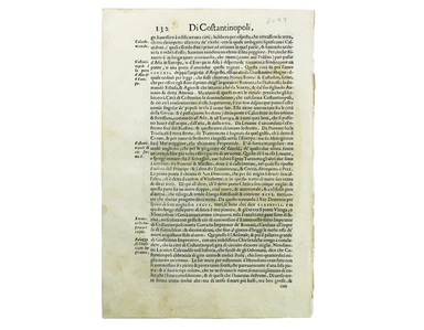
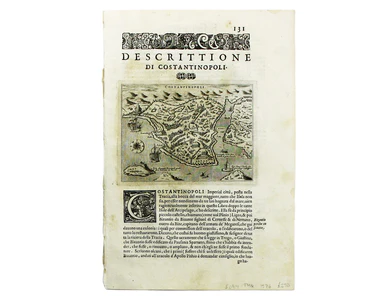
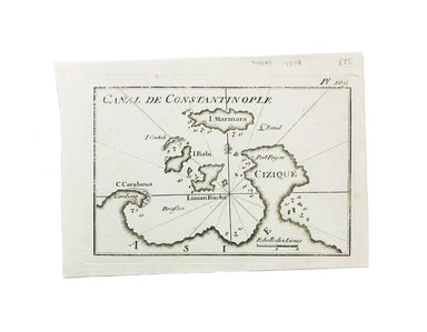
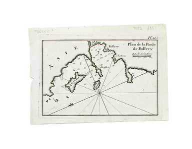
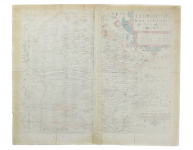
Blaeu’s Carte à Figure of Europe
Blaeu's 'carte à figure' map of Europe features ten costume vignettes and nine city views around the edges with galleys, galleons, sea monsters, be...
View full detailsBlaeu's 'carte à figure' map of Europe features ten costume vignettes and nine city views around the edges with galleys, galleons, sea monsters, be...
View full detailsCondition & Materials Lithographed in red and black on two sheets, each 38.5 x 80 cm; this map of Long Island is printed on thin india paper; ...
View full detailsMagnae Britaniae et Hiberniae Tabula First published in 1631, this map of the British Isles became the Blaeu firm’s principal one for twenty years....
View full detailsA Map of the Metropolitan Boroughs within the County of London The date of publication in the lower margin of this map is significant: 25th October...
View full detailsMogg’s New Map of the Roads. A New Travelling Map of England, Wales and Scotland […] Condition & Materials Copper engraving, 77 x 63.5 cm, a ro...
View full detailsJohn Stow's A Survey of the Cities of London and Westminster was originally published in 1598 and 1603, but revised and expanded works under his na...
View full detailsCondition & Materials Copper engraving, 19 x 25 cm, recent hand-colour, blank verso; a plan of Tower Ward published in Noorthouck’s History of ...
View full detailsJohn Stow's A Survey of the Cities of London and Westminster was originally published in 1598 and 1603, but revised and expanded works under his na...
View full detailsPlan of Coleman Street and Bassishaw Wards; Plan of Portsoken Ward; Plan of Cripplegate Ward Condition & Materials Copper engraving, 34 x 22 cm...
View full detailsA New and Correct Map of the Countries Twenty Miles round London Condition & Materials Copper engraving, 34 x 39 cm, recent hand-colour, blank ...
View full detailsThis view of Constantinople isfrom Mallet’s Description de l’Univers, first published in Paris in 1683 and reprinted with German text in Frankfurt ...
View full detailsThis plan of Constantinople is from Mallet’s Description de l’Univers, first published in Paris in 1683 and reprinted with German text in Frankfurt...
View full detailsConstantinopoli / Descrittione di Constantinopoli First published in 1572, our example of Porcacchi’s map of Constantinople is from the second edit...
View full detailsThis map of Ancient Jerusalem is from Mallet’s Description de l’Univers, first published in Paris in 1683 and reprinted with German text in Frankfu...
View full detailsKarte von der Küste von Angola von dem Flusse Bengo bis an den Fluss Quanza This map show the coastline of northern Angola between the rivers Bengo...
View full detailsThis map of Alexandria is from Mallet’s Description de l’Univers, first published in Paris in 1683 and reprinted with German text in Frankfurt the ...
View full detailsThis map of ancient Egypt is from Mallet’s Description de l’Univers, first published in Paris in 1683 and reprinted with German text in Frankfurt t...
View full detailsDapper’s plan of Cairo follows Matteo Pagano’s magnificent 21 sheet wall map, published in Venice in 1549. Cairo was one of the great trading centr...
View full detailsThis map of Africa was drawn and engraved by Edward Weller, and includes insets of Mauritius, Réunion and Natal, Some of the most recent geographi...
View full detailsThis map of the continent of Africa is from Mallet’s Description de l’Univers, first published in Paris in 1683 and reprinted with German text in F...
View full detailsInsula S. Laurentii, vulgo Madagascar The name 'Isle of St Laurence' was given by the Portuguese, who landed on Madagascar on St Laurence's day (Fe...
View full detailsThe practical pocket sea atlas by Marseilles hydrographer Joseph Roux, charting the ports and harbours of the Mediterranean, remained popular half ...
View full detailsThis sea chart shows the environs of Marmara Island on the southern coast of the Sea of Marmara, Turkey. The practical pocket sea atlas by Marseill...
View full detailsA sea chart of Foça, Turkey; near Smyrna. The practical pocket sea atlas by Marseilles hydrographer Joseph Roux, charting the ports and harbours of...
View full detailsCarte de L’Arabie, du Golfe Persique et de la Mer Rouge, avec L’Egypte, La Nubie et L’Abissinie This map of Arabia is from the Atlas de Toutes Part...
View full detailsThis map of the sources of the Nile is from Mallet’s Description de l’Univers. Condition & Materials Copper engraving, 14.5 x 10.5 cm, recent ...
View full detailsAlbanie, Grand Armenie, Colchide et Iberie selon les anciens This map of the Ancient Caucasus is from Mallet’s Description de l’Univers. Condition ...
View full detailsTabula Aphricae II Ruscelli’s map of North Africa, following Gastaldi, was first issued in his edition of Ptolemy’s Geographia printed by Valgrisi ...
View full detailsThis map of ancient Egypt is from Butler's Atlas of Ancient Geography and was engraved by Sidney Hall. Condition & Materials Copper engraving,...
View full detailsCondition & Materials Copper engraving, 14.5 x 10.5 cm, recent hand-colour, light waterstaining in upper margin, French text on verso, from Ma...
View full detailsThis map of São Salvador is from Mallet’s Description de l’Univers. São Salvador was once the capital of the kingdom of Congo, but as M’banza-Kongo...
View full detailsCondition & Materials Copper engraving, 15 x 10.5 cm, recent hand-colour, French text on verso, from Mallet’s Description de l’Univers.
Chapelle du St Sepulchre de N.S. Jesus Christ à Jerusalem The Church of the Holy Sepulchre, Jerusalem, from Mallet’s Description de l’Univers. Cond...
View full detailsDu Nil et ses Embouchures et des Crocodiles This map of the Nile delta (with crocodiles) is from Mallet’s Description de l’Univers. Condition &...
View full detailsBiledulgerid en General This map of North Africa is from Mallet’s Description de l’Univers. Condition & Materials Copper engraving, 15 x 10.5 ...
View full detailsCondition & Materials Copper engraving, 52.5 x 26.5 cm; a chart of the Caspian Sea after Jean Baptiste Bourguignon d'Anville, black and white, ...
View full detailsThis map of Oxfordshire was engraved by Emanuel Bowen for John Owen’s Britannia Depicta, a pocket road book derived from Ogilby’s innovative atlas ...
View full detailsNorthumbria, Cumberlandia et Dunelmensis Episcopatus This map of northern England is from the first edition of Tabularum geographicarum contractaru...
View full detailsThis map of Middlesex was engraved by Emanuel Bowen for John Owen’s Britannia Depicta, a pocket road book derived from Ogilby’s innovative atlas of...
View full detailsThis map of Middlesex was first published in 1746 to accompany Thomas Read’s English Traveller. The the plates were acquired by John Rocque and re-...
View full detailsCondition & Materials Copper engraving, 15.5 x 15.5 cm, modern hand-colour, blank verso; a map of Middlesex engraved by Toms for Thomas Badesla...
View full detailsThis map of Middlesex was published in Geographia Magnae Britanniae, or, Correct Maps of all the Counties in England, Scotland and Wales. It was pr...
View full detailsThis map of Middlesex is from Wallis' Pocket Edition of the English Counties. James Wallis (fl. 1810-1825) was born in Southampton in 1784, the son...
View full detailsThis characteristically clear and elegant map of Lincolnshire is by John Cary, one of the leading cartographic engravers, publishers and globe-make...
View full detailsLincolniae Comitatus ubi olim insederunt Coritani This map of Lincolnshire is from the second edition of Philemon Holland’s translation of Camden’s...
View full detailsThis map of Kent is from Wallis' Pocket Edition of the English Counties. James Wallis (fl. 1810-1825) was born in Southampton in 1784, the son of a...
View full detailsHertfordiae Comitatus This map of Hertfordshire is from the second edition of Philemon Holland’s translation of Camden’s Britannia into English, th...
View full detailsThis map of Herefordshire is by Moule, a bookseller, writer on heraldry and publisher who commissioned what is generally considered to be the last ...
View full details