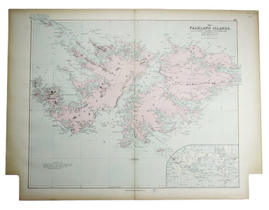
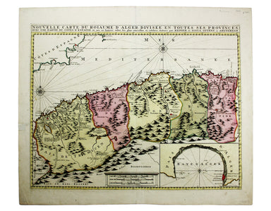
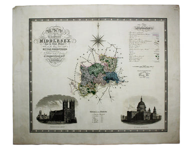
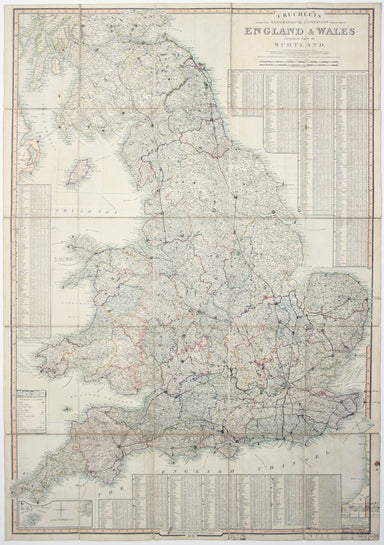
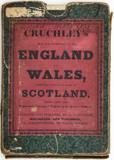
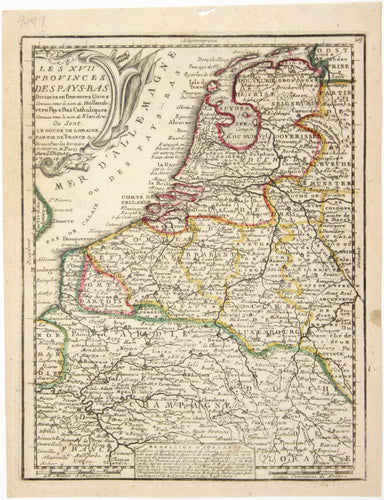
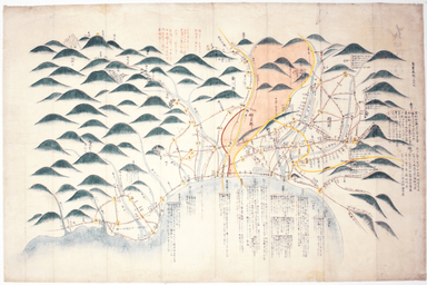
Badeslade & Toms’ Map of Middlesex
This map of Middlesex was engraved by Toms for Thomas Badeslade’s ‘Chorographia Britanniae’, an attractive pocket atlas which according to Badeslad...
View full details
This map of Middlesex was engraved by Toms for Thomas Badeslade’s ‘Chorographia Britanniae’, an attractive pocket atlas which according to Badeslad...
View full details
This map shows the Swedish Empire, including Finland and Swedish Livonia. It waspublished in Chiquet’s ‘Le nouveau et curieux atlas géographique et...
View full details
Estats du Grand Duc de Moscovie ou de l’Empereur de la Russie Blanche This map of Muscovy, or European Russia, was published in Chiquet’s ‘Le nouve...
View full details
Les estats de la Couronne de Pologne This map of the Crown of the Kingdom of Poland was published in Chiquet’s ‘Le nouveau et curieux atlas géograp...
View full details
Les Royaumes de Portugal et d’Algarve This map of Portugal was published in Chiquet’s ‘Le nouveau et curieux atlas géographique et historique ...’....
View full details
La Judée ou Terre Sainte, divisée en ses douze Tribus This is the second state of Robert de Vaugondy’s Old Testament map of the Holy Land. The map ...
View full details
Het Beloofde Landt Canaan door wandelt van onfen Salichmaeker Iesu Christo, nessens syne Apostelen Oriented to the west, this map of the Holy Land ...
View full details
This map of Lisbon was engraved by Josiah Henshall after William Barnard Clarke. It was published by the Society for the Diffusion of Useful Knowle...
View full details
This map of Asia was published in ‘Oddy’s New General Atlas of the World’. New South Wales appears here on the west coast of ‘New Holland’. James W...
View full details
This map of Africa features was published in ‘Oddy’s New General Atlas of the World’. It features an inset of the Azores and Cape Verde islands. Mu...
View full details
[Title page: Atlas Novus, volume IV] This is an architectural title page, engraved for the fourth volume of Blaeu’s Atlas Novus. The central panel ...
View full details
Clang, clang, clang went the trolley… Trolleybus services were introduced to London in 1931 and phased out between 1954 and 1962, making this one o...
View full details
Originally published in the series ‘Twenty-Four Views in Hindostan’, a part-work issued 1802-1805 to illustrate Francis Blagdon’s ‘Brief History of...
View full details
Sold by John Bowles, Print and Map Seller over against Stocks Market This print was issued in ‘London Described’ but like so many of the views in t...
View full details
From ‘Sketches at Home and Abroad’, printed by Charles Hullmandel for Charles Tilt. London Bridge and the Monument can be glimpsed through a forest...
View full details
The Opening of the New London Bridge by their most Gracious Majesties William the 4th & Queen Adelaide Our print depicts the river pageant cele...
View full details
This view is from 'Isolario dell'Atlante Veneto', perhaps the last of the great Italian ‘island books’. If Coronelli’s St Paul’s differs somewhat f...
View full details
Gezigt van den Tuin van Somerset’s Paleis, Langs den Theems tot op de Brug van Londen This view was engraved by . Philips after Antonio Canaletto’s...
View full details
Prospectus majoris viae, et Ecclesiae Sanctae Mariae in Londino / La Grande Ruë et l’Eglise Ste. Marie Jean François Daumont (fl. 1740-1775) was a ...
View full details
‘London as it is’ was printed for Boys by the pioneering lithographer Charles Hullmandel in two distinct versions: ours was originally sepia tinted...
View full details
Collins’ Chart of the Black Sea/Collins’ New Map of the Black Sea, shewing all the fortifications &c on an extended scale. Contemporary with th...
View full details
Asia veteribus nota. L’Asie ancienne, dirigée par M. Philippe This is a map of Asia as it was understood in the Greco-Roman world in classical anti...
View full details
This map of West Canada was engraved by John Rapkin for the ‘Illustrated Atlas’. The map also includes black and white vignettes of Kingston, Ontar...
View full details
South America – British Guiana – Georgetown and mouths of Demerara and Essequibo Rivers This British chart of Georgetown shows soundings etc, with ...
View full details
This chart of Dublin bay shows soundings etc, with interior detail of relief and settlements (including eastern Dublin), and inset coastal profiles...
View full details
This British chart of Durban port was engraved by John and Charles Walker. It shows soundings etc, interior detail of relief and settlements includ...
View full details
Quintilian; Marcus Fabius Quintilianus: [Institutio Oratoria] [colophon: impressum Florentaie [Florence] opera & sumptu Philippi Iuntae …] 1515...
View full details
Johnson’s last great work contains a great deal of anecdotal information which might otherwise have been lost. It was first published as ‘Prefaces,...
View full details
Underground Map of Central London/A Guide to Underground Travel, Through Service Sth. Harrow and the West End Leboff and Demuth draw attention to t...
View full details
Underground Railways of London/What to see and how to travel: Map of the Electric Railways of London The continuation of lines in the margins is no...
View full details
Chart of the World on Mercator’s Projection, shewing the principal Ocean Steam Routes, the Submarine Telegraph &c This world map was published ...
View full details
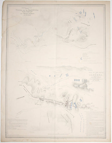
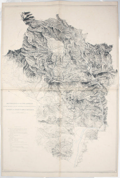
The Falkland Islands, surveyed by Captains Robert Fitz Roy R.N., William Robinson R.N. and Bartholomew James Sulivan R.N. This map of the Falkland...
View full details
Joannes Janssonius II (1588-1664) married into the Hondius family and, with Henricus Hondius, worked on a revised edition of the Mercator-Hondius a...
View full details
A correct sketch of the northern seat of war, exhibiting the whole of the country, wherein the British troops under the command of His Royal Highne...
View full details
Plan du Siege de Namur avec les nouveaux travaux que sa Majesté y a fait adjouter qui sont marquees à la lettre A. Cette place fut reduitte à l’obb...
View full details
Carte générale des découvertes de l’Amiral de Fonte, representant le grande probabilité d’un Passage au Nord Ouest Maps depicting the purported voy...
View full details
Sinus Gangeticus; vulgo Golfo de Bengale nova descriptio This is a map of the Bay of Bengal with north oriented to the right. Petrus Schenk and Ger...
View full details
Karte von dem groessten theil des landes Jemen, Imame, Kaukeban &. &. […] This map of Yemen and the Red Sea follows the detailed maps by Ge...
View full details
This map of Algeria features an inset of the Bay of Algiers. Ottoman Algeria was a hub of privateering and the Mediterranean slave trade. Well know...
View full details
Plan Des Villes De Londres et de Westminster et leurs Faubourgs avec le Bourg de Southwark This is the first version of the map, before the date wa...
View full details
Map of the Occupied Areas / Carte des Zones d’Occupation / Karte der Besatzungs-Zonen mit Neuen Postleitgebieten / [in Cyrillic:] Karta Okkupacionn...
View full details
La VIII Table d’Angleterre/Anglesey, Wight, Vectis olim, Garnsey, Iarsay Islands around the British coast were often grouped, in various combinatio...
View full details
Blaeu and the rival Golden Age Dutch cartographic publishing house of Janssonius raced to bring out atlases of the British Isles in the 1630s and e...
View full details
Blaeu and the rival Golden Age Dutch cartographic publishing house of Janssonius raced to bring out atlases of the British Isles in the 1630s and e...
View full details
Blaeu and the rival Golden Age Dutch cartographic publishing house of Janssonius raced to bring out atlases of the British Isles in the 1630s and e...
View full details
Map of the County of Middlesex from an Actual Survey The Greenwood brothers were land-surveyors from Yorkshire who compiled one of the last indepen...
View full details
Map of the County of Surrey from an Actual Survey The Greenwood brothers were land-surveyors from Yorkshire who compiled one of the last independen...
View full details
This map of Gloucester was engraved by Johannes Kip for 'The Ancient and Present State of Glostershire'. It is one of the earliest views of the cit...
View full details