

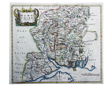
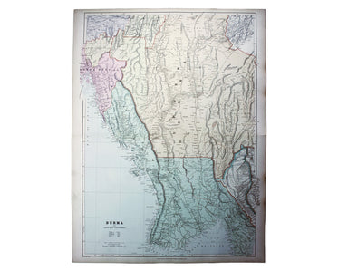
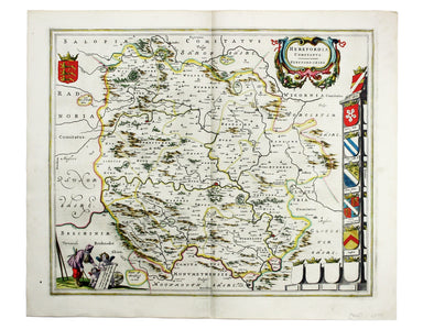
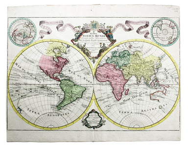
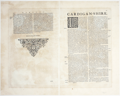
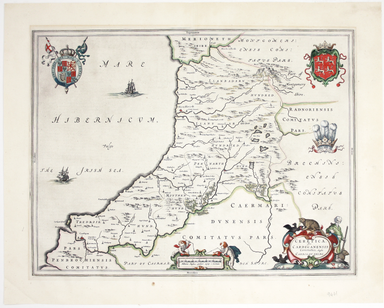
Morden's Map of Hampshire
Robert Morden's maps were engraved to illustrate Gibson's edition of William Camden's Britannia, first published in 1695 and reprinted in various e...
View full detailsRobert Morden's maps were engraved to illustrate Gibson's edition of William Camden's Britannia, first published in 1695 and reprinted in various e...
View full detailsDaciarum, Moesiarumque, vetus descriptio This map of Ancient Dacia and Moesia, modern Romania and Bulgaria on the Black Sea was published by Baltha...
View full detailsThis intricate anthropomorphic map (the artist also produced a zoomorphic companion piece) was issued soon after the outbreak of the First World Wa...
View full detailsBacon’s Large Scale Plan of the City of London –Bacon’s Coloured Plan of the City of London… “Blitzed” areas shown A highly detailed map of London ...
View full detailsProctor, Robert: Narrative of a journey across the Cordillera of the Andes and of a residence in Lima and other parts of Peru in the years 1823 and...
View full detailsHesiod: Hesiodo Ascraei poetae vetustissimi ac sapientissimi opera, quae quidem extant, omnia Graecè, cum interpretatione latina è regione, ut conf...
View full detailsArnobius: Adversus Gentes Libri VII. Cum Recensione Viri Celeberrimi, & integris omnium commentariis. Editio novissima atque omnium accuratissi...
View full detailsThis map of Burma was published in the second trade edition of Stanford’s London Atlas. Edward Stanford (senior) acquired Arrowmsith's stock in 187...
View full detailsThis map attempts full integration of bus and coach routes, tramways, the Underground and main-line railways, and is possibly the first issue showi...
View full detailsIn 1933 the Met became part of the LPTB. Here though, the Tube and other railways fade into the background. The emphasis is on work/life balance, c...
View full detailsThis map of Reading is from Hermannides' Magna Britannia. Nearly all of the plans are based on the small inset plans shown on John Speed's county m...
View full detailsMaximus of Tyre: [Greek title] Sermones sive Disputationes XLI. Graece nunc primum editae. [Geneva]: ex officina Henrici Stephani Parisiensis typog...
View full detailsOppian: [Greek title:] Alieutikwn biblia pente... Kynhgetikwn biblia tessara. Oppiani de piscibus libri V. Eiusdem de venatione libri IIII. Oppiani...
View full detailsDiogenes Laertius; Eunapius of Sardis: [...] De Vitis, dogm. & apophth. clarorum philosophorum, Libri X. Heschyii ill. de iisdem philos. & ...
View full detailsAeneas of Gaza; Zacharias, Bishop of Mytilene: De immortalitate animae, et mortalitate universi, ex recensione et cum animadversionibus Casparis Ba...
View full detailsBlaeu’s map of Herefordshire. Blaeu and the rival Golden Age Dutch cartographic publishing house of Janssonius raced to bring out atlases of the Br...
View full detailsThe Bay of Gibraltar. With a plan of the Town, Rocks and Fortifications of Gibraltar as they now are. Also a plan of Algezira… Copied from the Drau...
View full detailsTrans-Isula D. Condition & Materials Copper engraving, 9.5 x 13.4 cm, recent hand-colour, Latin text on verso; map of Overjissel.
The Seven United Provinces This map of the Netherlands was prepared for Playfair’s New General Atlas. Condition & Materials Copper engraving, ...
View full detailsThis map of Poland is from Mallet’s Description de l’Univers. Condition & Materials Copper engraving, 14.5 x 10.5 cm, recent hand-colour, Fren...
View full detailsThis plan of Tienen in Flanders is from the Civitates Orbis Terrarum, one of the most significant cartographic works of the late sixteenth-century,...
View full detailsPlan du Dock ou du Bassin ‡ flot ‡ Londres dit Katarinen Dock ou Dock St. Katharine. Condition & Materials Lithograph, 35 x 40.5 cm, black and ...
View full detailsMappa Totius Mundi adornata juxta Observationes dnn. Academiae Regalis Scientiarum et nonnullorum aliorum secundum annotationes recentissimas edita...
View full detailsAfbeeldinge van’t zeer vermaarde Eiland Geks-Kop This Dutch ‘fool’s cap’ map satirises the bursting of the financial bubbles of 1720. Cartographic ...
View full detailsSigned limited edition screenprint Colour screenprint, sheet size 78 x 57.5 cms, signed by the artist and inscribed 'AP' (Artist’s Proof) in pencil...
View full detailsTopographia Repraesentio Barbarici Portus et Urbis Munitae Oran … Oran, an important trading port and now Algeria’s second city, was governed by th...
View full detailsLucan: [...] Pharsalia, cum notis Hugonis Grotii, et Richardi Bentleii. [Twickenham] Strawberry-Hill 1760 The only classical text and "most disting...
View full detailsAn illustrated record of important events in the annals of Europe, during the last four years: comprising a series of views of the principal place...
View full details“Hell on Wheels” War Against the Axis 1942 – 1943 – 1944 The lower panel of this map deals with operations in North Africa and Sicily, with the uni...
View full detailsFirst published in 1914, this revised edition highlights administrative boundaries. Though technically administered jointly by Egypt and Britain be...
View full details[Greek title: Demosthenous logoi, kai prooimia demegorika, kai epistolai: syn tais exegesesin ophelimotatais, tou Oulpianou rhetoros, te ton palaio...
View full detailsThis map of Frankfurt, view of the city at the foot of the map, was published by the SDUK. The Society for the Diffusion of Useful Knowledge was fo...
View full detailsCeretica sive Cardiganensis Comitatus; Anglis Cardigan Shire Blaeu and the rival Golden Age Dutch cartographic publishing house of Janssonius raced...
View full detailsBusca, near Cuneo in Piedmont. Blaeu’s townbook of Savoy and Piedmont was first published by the Blaeu heirs in 1682, but the plates were purchased...
View full detailsPresentation copy inscribed to Edmund Grosse. The Brotherton Library in Leeds possesses another copy, inscribed "From the author", and with Gosse's...
View full details